![Logo AttriX Bleu.svg]](https://support.attrix.ca/hubfs/Logos/AttriX/Logo%20AttriX%20Bleu.svg)
Since the last update, the display of locations has been modified in the driver log and daily logs of MyGeotab to comply with the DCE mandate regulations in Canada.
Geolocation should now be displayed in a description including the distance and direction to the nearest reference point corresponding to a city, town, municipality, or location on a road.
This is why the exact address is no longer listed on the driver's daily logs.
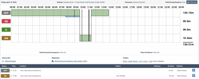
If needed, complete addresses are available in the trip calendar. To quickly access them, simply tap on the blue geolocation bubble located to the right of each status change in MyGeotab.
Reference Technical Standard
4.4.2 Conversion to Geolocation
a) For each event including vehicle position information, the DCE must convert the vehicle position automatically entered as latitude and longitude coordinates into geolocation information indicating the approximate distance and direction to the nearest reference point corresponding to a city, town, municipality, location on a road, or legal subdivision, as well as the abbreviation of the province, territory, or state.
b) Geolocation information for all provinces and territories of Canada must be extracted from a database containing all locations (cities, towns, municipalities, etc.) listed in the most recent Canadian geolocation database available on the CCMTA website and described in provision 6 of this standard.
c) DCE outputs (such as printed reports or the DCE screen) must present geolocation information in the form of place names in text format.
d) Conversion to geolocation, for the purpose of DCE compliance with this provision, refers to the conversion of latitude and longitude coordinates without using cellular communication services.