Update: MyGeotab 21.02
Here are the new features offered in Geotab Drive with update 2102. Database updates are done gradually to ensure a smooth migration. Therefore, it is impossible to know the effective date of version 21.02. To see the current version of your database, simply navigate to the Administration tab > About: Version 5.7.2102
Article Content:
- New design
- Dashboard
- Reports
- Map
- Geotab's Analytics Lab
- Renamed tabs
- Users
- Maintenance reminders
- Engine faults
- Public Works integration
- General improvements
- Safety Check Rounds (DVIR)
New Design
If you haven't activated the feature preview, MyGeotab may look slightly different for this version. As announced in our 21.01 deployment, the Geotab Product and Design team have worked hard to maximize features, encourage exploration, and simplify your experience with an enhanced new look. They've kept things simple with clear text, increased contrast, and carefully organized elements. Navigation is more intuitive, and user actions are more distinct. This version will be applied by default during the 21.02 update.

Dashboard
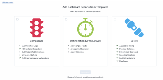
New and improved integrated dashboard reports Geotab has removed from their current suite of integrated reports and replaced them with new contemporary reports that make sense for your business. The following reports are enabled by default:
- Idle time violations
- Watchdog
- Fleet utilization
- Fleet distance trend
Geotab has also added 17 new integrated reports in the databases:
- Active engine faults
- Aggressive driving
- Idle time violations
- Potential collisions
- Average fuel economy
- Driver safety scorecard
- Speeding violations
- Seat belt usage
- Maximum speed
- Fleet distance trend
- Asset utilization
- Fleet utilization
- Unidentified driver ELD daily logs
- ELD diagnostics and anomalies
- Unverified ELD daily logs
- HOS violations analysis
- Unrepaired defects
*Note* These reports are not automatically activated on the dashboard. To activate them, you need to go to the Dashboard section and select the templates you desire.

Reports
Faster reports, ready when you need them.
To support large fleets and date ranges, Geotab has added features to improve the performance of their risk management report and exception summary. Faster execution time means faster access to information.
Map
Advanced live map view (feature preview)
Fleet owners can now view asset details while tracking their position on the live map. This is useful for fleets that want to monitor the current status of their assets, e.g., temperature, charge status, fuel level, etc.
To access this view, you need to press the "Advanced" button.

This will allow you to view asset details while still seeing the location of your vehicles on the map.

Geotab's Analytics Lab
Geotab's Analytics Lab is now available to all customers.
In 21.01, Geotab introduced the Marketplace Analytics Lab add-on, a suite of experimental applications designed to provide performance insights that help fleets make informed business decisions. For this version, Analytics Lab is installed by default and available to all MyGeotab users. Using fleet telematics data, Analytics Lab combines easy-to-use applications with models to analyze, visualize, and uncover trends in your fleet operations.

Renamed tabs
Vehicles tab
The vehicle tab has been modified and is now called Vehicles and Assets.
Telematics is no longer limited to vehicles. MyGeotab is a full-service IoT platform that can connect to any asset, including trailers, generators, and other industrial equipment. To better reflect data acquisition capabilities, Geotab has changed the Vehicles tab to Vehicles and Assets in the main menu, and the term vehicle is now called assets throughout the application.
For compliance-related features such as logs (HOS) and Safety Check Rounds (DVIR), the term vehicle will be retained.
Safety Check Rounds (DVIR) tab
The Safety Check Rounds (DVIR) tab is now called Asset Inspection.
To better support customers worldwide, Geotab has renamed this tab to Asset Inspection.

Users
Users Adding new currencies
Users can now select their currency for maintenance reminders for anything related to costs. For fleets that regularly cross borders, the application supports currency conversion.

Profile customization
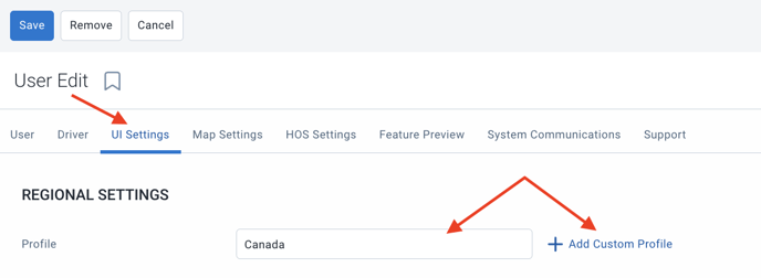
Users can now select their regional measurement unit for units displayed on the Engine Measurements page, from their IU parameter. Users can also create custom profiles if there are no appropriate default settings to choose from.

Maintenance reminders
New maintenance cost columns in reports and import template.
Geotab has added new columns to the Data and Summary report tabs for total maintenance costs of assets. Users can also import asset maintenance costs from the import template.
New date selector options for upcoming maintenance
For quick access to upcoming maintenance events, Geotab has added options for next week and next month in the date selector.

Engine faults
The engine faults page has been improved.
The engine fault page has been enhanced and now includes:
- Compact display of the table.
- Ability to show/hide columns.
- Filtering options by source (vehicle or telematics) and/or protocol.
- Total number of times a fault has been recorded.
- View options for error code, description, current status, and more.

New filter options added
Added new filter options to engine fault reports. These options are also available for the dashboard and email reports. Faults can be filtered by:
- Failure source (vehicle/telematics).
- Engine protocol.
- Engine diagnostics.
Public Works
Public Works New Public Works route completion reports (feature preview)
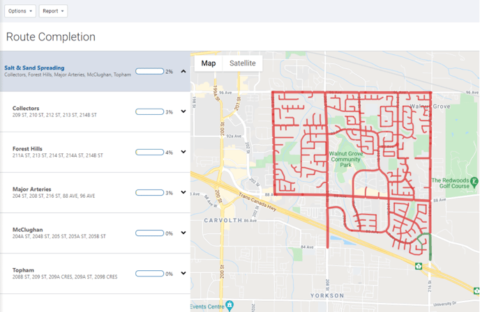
To ensure that valuable infrastructure is adequately maintained while controlling costs and tracking material usage, route completion features are now available for Geotab Public Works users. Government agencies managing assets such as salt spreaders, snowplows, street sweepers, and waste management assets will find this feature useful for complying with maintenance and service standards.

Geotab has also added two new integrated reports: standard and advanced route completion reports.
Ability to upload a Shapefile for route completion (feature preview)
Routes can now be uploaded to MyGeotab. To do this:
Administration > System > System Settings > Route Completion
Simply drop your Shapefile into the designated area.
New route-based option for equipment management report (feature preview)
Equipment management reports can now be generated for all uploaded route completions. This new report provides detailed and summary totals for winter operation materials (solids, pre-wets, anti-icers) and operation activities (spreading time, snow removal distance), by service group, route group, and routes.
General improvements
- Fixed issues and added new translations
- Increased zone activity search to 72 hours instead of 24 hours
- Added "select all" option in the filter on the Zones page for bulk editing.

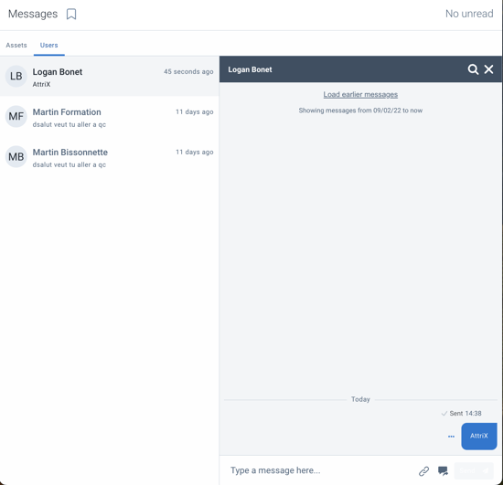
- Added a checkbox to indicate the status of a message (sent, received, read)

- Added sections for number and phone and website in the company profile section in system settings.

- Added the ability to reject new installation records.
Safety Check Rounds (DVIR)
To be consistent with the Geotab Drive application, the failure column in Safety Check Rounds reports now uses Minor and Major as severity types instead of Normal and Critical.
A blue arrow indicates a minor failure while a red arrow indicates a major failure. These arrows now replace the red C or blue N from version 21.01.
